
Starting point Burgerbrug

Routes from this starting point
-
Green route from starting point Burgerbrug (green)
- 4.8km
-
Red route from starting point Burgerbrug (red)
- 3.78km
-
Blue route from starting point Burgerbrug (blue)
- 8.48km
-
Orange route from starting point Burgerbrug (orange)
- 3.51km
wandelkaart startpunt Burgerbrug (2718 kb)
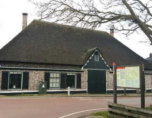
The village of Burgerbrug was founded immediately after the fourth and final dyking and reclamation of the Zijperwad in 1597. It takes its name from the bridge over the Groote Sloot, the wide central canal of the Zijperpolder. Burgerbrug developed along two intersecting axes, with linear settlement along the Groote Sloot and the Burgerweg. The monumental stolp farmhouses – traditional Dutch farmhouses built in the shape of a cheese cover – stand mainly along the Groote Sloot, such as at no. 25 Vroegop, a grand example from 1670, and at no. 73 Starre Kroon from 1797. Only a few of the once numerous polder windmills remain. They are identified by letters, referring to their respective polder sections.
- The green route runs along the water storage area to the ‘De Zuider G’ windmill, an octagonal smock mill from 1597. It crosses the canal over ‘Kramer’s footbridge’ and continues along a farm track to the Westfriese Zeedijk.
- The red route follows the eastern side of the Groote Sloot, then runs along a farm track straight across the polder towards the Westfriese Zeedijk. It returns along the Burgerweg to the start.
- The blue route runs along the quiet western side of the Groote Sloot to the ‘De F’ windmill. A farm track belonging to the Ruijter family leads to the Noordhollandsch Canal. After the winding Westfriese Zeedijk, the route runs back into the polder on the eastern side, along a farm track belonging to the Boontjes-Duyvis family.
- The orange route runs together with the blue route but returns along the Ruigeweg. The route is waymarked with dark orange arrows.