
Starting Point Wieringen

Routes from this starting point
-
Havenroute (rood)
- 4.45km
-
Oosterlandroute (blauw)
- 9.61km
-
Groene Ringdijkroute
- 11.82km
-
In the footsteps of Saint Willibrord
- 26.9km
To the west of Den Oever, the land rises gently to the five-metre-high boulder clay hill of the old village of Oosterland. The hill was pushed up by Scandinavian glaciers during the Ice Age and later covered with sand and humus. This raised landscape of Wieringen formed the former island where Vikings once lived and left behind a substantial treasure.
Today, Den Oever is mainly supported by fishing and recreational boating on the Wadden Sea. In the past, this was different: lightering on the shallow Zuiderzee east of the island provided most employment. Deep-draught sea vessels were ‘lightened’ there by transferring their cargo to flat-bottomed barges (‘lichters’), which then sailed further south to the Hanseatic cities. After the construction of the Noordhollandsch Canal in 1824, this activity declined, leaving fishing and smallhold farming as the main livelihoods. The fishing harbour dates only from around 1900; before that, the flat-bottomed Wieringen boats were moored along the dyke or a longitudinal embankment.
- The red Haven Route explores the village and its harbours, with views from the Stontelerdijkje over the locks and quays of the Afsluitdijk (1930). The route is waymarked in both directions with red arrows.
- The blue Oosterland Route continues further: along the northern edge of the 19th-century Waard-Nieuwland polder to the elevated village of Oosterland and the hamlet of Vatrop. There are also fine views over the Wadden Sea. The route is waymarked in both directions with blue arrows.
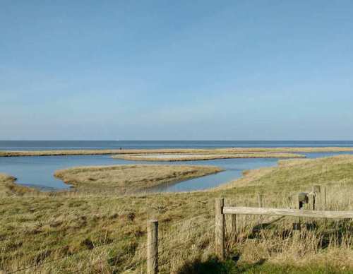
- The green Ringdijk Route runs along the eastern ring dyke of the Waard-Nieuwland polder and crosses the polder towards Oosterland and the Wadden Sea dyke, including a stretch along the farm track of Jaap and Nils Koorn. On the return, the route passes the bird hide at Kleiput Vatrop and continues with views over the Wadden flats towards Den Oever. The route is waymarked in both directions with green arrows. Parts of the route are not mown frequently.
The Noord-Hollandpad is a long-distance walking route (284 km), divided into 16 stages, running from Texel to Huizen. It crosses the inland landscapes of Noord-Holland along farm tracks, past windmills, ditches, canals and woodland, and through distinctive villages. The route is signposted in both directions. Stage 6 runs from Den Oever to Kolhorn (29 km). See www.noordhollandpad.nl for more information.
Read about the relationship between Wieringen and Seaweed.