
Starting Point Dijkgatbos

Routes from this starting point
-
Dijkgatbos Route (blue)
- 2.31km
-
Sluitgatbosroute (yellow)
- 3.07km
-
Dijkgatsweide Route (black)
- 5.25km
-
Wieringermeerdijk Route (purple)
- 5.98km
Dijkgatbos has a remarkably mature feel for a young, post-war polder woodland. It resembles an old inland dune woodland or a woodland on glacially formed hills. In that sense, something positive emerged from a senseless act of retaliation by the Germans on 17 April 1945, when they blew up the IJsselmeer dyke in two places, flooding the entire polder. The deeply eroded breach pools from that time – the Noordelijk Wiel and Zuidelijk Wiel – still bear witness. After the polder was drained again, large quantities of sand from the two pools had been washed into the surrounding land, to the extent that arable farming was no longer viable. It was therefore decided to plough the sand as deeply as possible into the soil and plant woodland. Dijkgatbos, also known as Sluitgatbos, is managed by Staatsbosbeheer (Dutch Forestry Commission). It offers excellent walking and opportunities for photography.
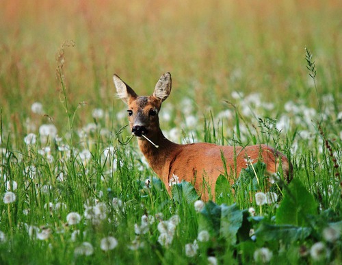
After the war, Germany donated two groups of roe deer as a gesture of reparation for flooding the polder. The animals find good cover in the varied polder woodland and feed on wildflowers and herbs along the woodland edges and grassy paths, as well as on leaves and buds from the dense undergrowth. There are now almost 100 roe deer in and around the woodland. Goshawks, woodcocks and kingfishers can also be seen, so it is worth keeping a lookout along the way.
- The blue Dijkgatbos Route explores the central part of the woodland and offers views over the Noordelijk Wiel and Zuidelijk Wiel. The route is waymarked in both directions with blue arrows.
- The yellow Sluitgatbos Route explores the southern part of the woodland, notable for its variety and subtle changes in elevation – perhaps the most attractive section. The route is waymarked in both directions with yellow arrows.
- The black Dijkgatsweide Route runs north to a water-rich bird paradise between Dijkgatbos and Robbenoordbos. The route is waymarked in both directions with black arrows.
- The purple Wieringermeerdijk Route also runs across the Dijkgatsweide along a footpath, stepping stones across a channel and along the woodland edge to the unpaved IJsselmeer dyke, with wide views over the polder and the lake. The route is waymarked in both directions with purple arrows.