
Helderse Duinen
Rate this route
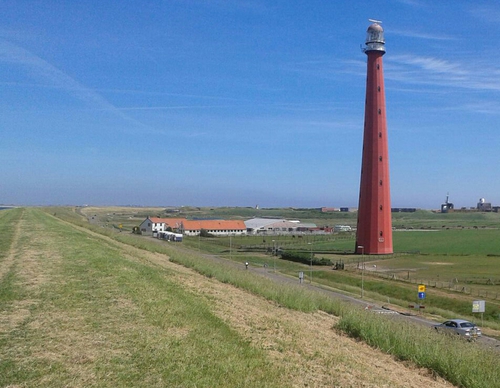
The ‘Helderse Duinen’ themed route combines nature, culture and the maritime history of Den Helder. It runs through dunes, woodland and polder landscapes, along winding paths in the dunes and also along the solid dyke with fine views over the sea, where naval vessels, submarines and sometimes seals can be seen. Along the way are historical forts, the distinctive Lange Jaap lighthouse and several museums. It is also possible to visit De Nollen and De Helderse Vallei. From the dyke, it’s just a short stroll to the town centre of Den Helder and the former naval dockyard Rijkswerf Willemsoord, with its historic ships and plenty of places to eat and drink for a well-earned break.
The route starts and ends at a railway station and is therefore easy to reach by public transport. It can be followed using the waymark posts of the Noord-Holland Hiking Network. More information is available on the NS website.
-
 To add this route in the app: scan the QR code from within the app. or enter the route number 78884 in.
 - 17.17 km
-
 Closed route
-
 Soon-to-be closed route
-
 Reports
-
 Hike point
-
 Starting point
-
 One-way path


| From | To | Segment length | Marking(s) | Characteristics | Reports |
|---|---|---|---|---|---|
|
Starting point den helder station |
0.53 km |
|
|
||
|
Startpunt willemsoord |
0.47 km |
|
|
||
|
Startpunt willemsoord |
0.81 km |
|
|
||
| 0.11 km |
|
|
|||
| 1.24 km |
|
|
|||
| 1.47 km |
|
|
|||
| 1.91 km |
|
|
|||
|
Startpunt liniedijk |
0.05 km |
|
|
||
|
Startpunt liniedijk |
2.37 km |
|
|
||
| 0.02 km |
|
|
|||
|
Starting point fort kijkduin |
0.31 km |
|
|
||
|
Starting point fort kijkduin |
0.2 km |
|
|
||
| 1.04 km |
|
|
|||
| 1.22 km |
|
|
|||
| 1.08 km |
|
|
|||
|
Starting point de helderse vallei |
0.56 km |
|
|
||
|
Starting point de helderse vallei |
0.16 km |
|
|
||
| 0.06 km |
|
|
|||
| 0.1 km |
|
|
|||
| 1.83 km |
|
|
|||
| 1.48 km |
|
|
|||
| 0.15 km |
|
|