
Den Hoorn

Routes from this starting point
-
Polderpad (blue)
- 6.38km
-
Neeltjesnol Route (orange)
- 7.98km
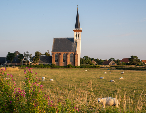
Den Hoorn's clay embankment has been inhabited for centuries. The village was once located along the sea and was called the Clijf. The All Saints’ Flood of 1170 turned the old Marsdiep into a tide race, after which fishermen settled further south on the resulting headland, Den Horn. This harbour town was destroyed by Frisian pirates in 1398 and the inhabitants returned to the Clijf, which has since been called Den Hoorn. In subsequent centuries, the inhabitants became well-known as pilots who guided ships through the unpredictable Marsdiep to and from the Reede van Texel. The construction of the North Holland Canal in the early 19th century meant the end of piloting, and sheep farming and flower bulb cultivation then became the dominant industries. The rich cultural history is still visible in the landscape: the ancient clay hill with former headlands, winding dikes and polders intersected by 'peerdepaadjes' (bridle paths) and 'tuunwallen' (garden walls). The old harbour lock and Loodsmansduin observation point also bear witness to the past. It’s a unique area and picturesque village to explore on foot.
- The Polderpad (blue) is a path that cuts across the grounds of the Novalishoeve farm, which is open to the public, and follows the historic route between the former harbour and the village, across the old headland where Den Horn once stood. You walk along farmland paths, winding dikes and narrow bridle paths.
- The Neeltjesnol Route (orange) leads south to the dune top overlooking the mudflats of Mok Bay, which is a bird paradise. Cross colourful polders and the dune edge, visit Lap's ‘boet’ (sheep farm) and enjoy the view at the bunker on Loodsmansduin.