
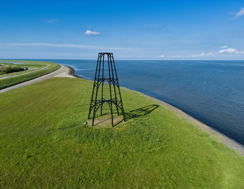
IJzeren Kaap

Routes from this starting point
-
Vissers Circular Walk (red)
- 5.28km
-
From Slufter to Kaap (green)
- 12.39km
The IJzeren Kaap marks the location of the Oosterend fishermen's 19th century oyster harbour. Texel oysters were famous at the time. The fishermen harvested the beloved shellfish using oyster dredges in the Wadden Sea and allowed them to grow bigger on oyster beds in the Wadden creek north of the village, where Het Noorden polder is now located. The small harbour at Nieuweschild provided a safe mooring spot for the little boats. In 1859, this small harbour fell out of use. The cast-iron structure was installed in 1854 as a beacon for shipping. The flameless beacon was visible only during the day, as was the church tower of Oosterend. The structure originally consisted of four levels but the first level has been underground ever since the dike was raised. It’s a striking landmark and a national monument.
The walking routes around Oosterend were created by ANLV De Lieuw Texel, along with the village committee and local farmers.
- The entirely paved Vissers Circular Walk (red) leads from the IJzeren Kaap along the dike and over quiet roads to Oosterend. In the picturesque fishing village, the circular walk route leads to the church square via cobbled streets and alleys.
- The From Slufter to Kaap linear walk (green) traverses the island and mainly crosses farmland in the polders of Eierland. It’s a delightful journey past fields and creeks between the Wadden Sea Dike and the North Sea. With its nature-friendly embankments, the Hogezandskil nature reserve has become a unique area for birds.