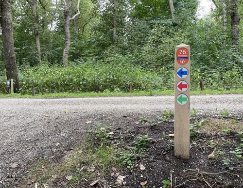
Starting point Tooleburg Hoofddorp

Routes from this starting point
-
Toolenburgerplas Walk (red)
Unpaved path (partly) - 2.97km
-
Floriande-Oost Route (blue)
Unpaved path (partly) - 7.86km
-
PARK21 Route (green)
Unpaved path (partly) - 11.94km
kaart startpunt Toolenburg Hoofddorp (1845 kb)
The Toolenburgerplas is an artificial lake created by sand extraction for the districts of Toolenburg and Floriande and was only commissioned for recreational use in 2003. In the future, the lake will be part of the large PARK21 between Hoofddorp and Nieuw-Vennep.
- The Toolenburgerplas Walk (red) leads through different zones around the Toolenburgerplas in Hoofddorp. The park zone offers opportunities for games and sports, while the water recreation zone is for surfing, swimming and fishing. In the nature reserve, sandy terrain alternates with dune vegetation and marshy areas. A nesting wall provides nesting opportunities for sand martins. There are cafés at the lake.
- The Floriande-Oost Route (blue) in Hoofddorp seeks out the sporty and adventurous sides of the Toolenburgerplas and PARK21 where swimmers, divers, surfers, climbers, walkers and nature lovers can all enjoy themselves. The route also leads through the Floriande-Oost district along the Cycladenarchipel area and the green border around the Altenapad.
- The PARK21 Route (green) leads through the outlying area between Hoofddorp and Nieuw-Vennep. A beautiful park design has been created for this area, parts of which are in different states of development. The landscape and the experience of the route will change considerably over the years. You can really enjoy the outdoors along the Toolenburgerplas, on the grassy eastern side of the bus lane, on the Nieuwe Vennep estate and in the park and amongst the brushland in the southern Meerbos Zwaansbroek, in the vicinity of the Pioniers sports fields.

