
Search results
Characteristics
Quick search
358 results
Region
Length
Characteristics
 (deels) gesloten")
Museum Tram Path (blue)
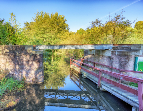
The Museumtrampath or Museum Tram Path (blue) follows the full length of the botanical parks. Via a clever little bridge under the railway, you will arrive at the footpaths through the public gardens on both sides of the Museum Tramway. You then walk around De Poel, the Bloesempark and over the
9.06 km- (2)
 (deels) gesloten")
Botanical Parks Walk (red)
The Ommetje Heemparken or Botanical Parks Walk (red) is charming in every season, but is especially breathtaking in the spring. Forest anemones, wild daffodils and summer snowflakes provide amazing splashes of colour. The sweet scents of wild hyacinths and hollowroots intermingle with the intense
2.79 km- (4)
 (deels) gesloten")
Olympic Route (purple)
The Olympiaroute or Olympic Route (purple) is a walk through the Stadionbuurt district. This district owes its name to the national stadium that used to be located on the Stadionkade. It was immediately demolished after the
5.62 km- (0)
 (deels) gesloten")
Schinkel Path (yellow)
The Schinkelpad or Schinkel Path (yellow) follows both sides of the banks of the Schinkel river, between the Overtoom and the Nieuwe Meer lake. Today, the Schinkel and the Kostverlorenvaart canal together form the main navigation route through Amsterdam. There are a lot of houseboats moored along
5.5 km- (2)
 (deels) gesloten")
Nature and Garden Route (yellow)
The Natuur- en Tuinenroute or Nature and Garden Route (yellow) takes you past a number of spots that are reminders of the Floriade of 1982, such as the municipal rose garden and the heather garden. Closer to the eastern side you will find the willow garden, with pollard willows still recognizable.
3.24 km- (1)
 (deels) gesloten")
Park Walk (blue)
The Parkommetje or Park Walk (blue) is a short walk along the water playground and the banks along the lake. The water in the Gaasperplas is remarkably clear and is good for swimming and fishing.
2.06 km- (1)
 (deels) gesloten")
De Zwarte Kat Walk (blue)
The Rondje De Zwarte Kat or De Zwarte Kat Walk (blue) takes you along the Amstel via the towpath to the spot where the De Zwarte Kat pub stood until recently. The pub was a popular stop for many cyclists and walkers during the previous century. The walk continues via the Simon Colenvaartpad, which
4.35 km- (1)
 (deels) gesloten")
Kruitmolenroute (red)
The Kruitmolenroute (red) is a stroll along charming polder paths through the Langs de Akker recreational area. You can wander through the meadows, but dogs are not allowed. The Kruitmolen lane leads to a historic site where a gunpowder mill exploded in 1782. Soon afterwards, a new powder factory
2.98 km- (0)
 (deels) gesloten")
Museum Tram Path (blue)
The Museum Tram Path (blue) follows the footpaths in the public gardens on either side of the track as closely as possible. The walk takes you through De Braak and the Jac. P. Thijssepark - which will treat you to stunningly beautiful flowers in spring - and around the Amsterdamse Bos, the
9.06 km- (7)
 (deels) gesloten")
Poel Walk (green)
The Poel Walk (green) is lovely in every season but especially lush during the summer. You can admire rare plants here, such as the southern marsh orchid and the carnivorous sundew. Highlights along the route include the steeple of the St. Urbanus Church in Bovenkerk and of course the Bloesempark.
5.62 km- (0)