
De Hors

Routes from this starting point
-
Waterral Path (red)
- 2.73km
-
Horspolders (blue)
- 3.68km
-
De Hoorn van Texel (black)
- 10.32km
kaart startpunt De Hors (661 kb)
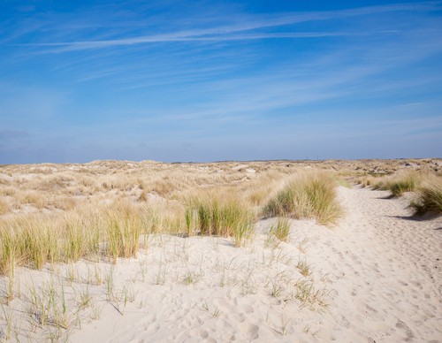
De Hors is a newer part of Texel, shaped by the sea and wind. This dynamic coastal area is constantly changing: sandbanks interweave, dunes appear and then disappear. The valleys are rich in flora and the south-western tip is a bird paradise with beach-nesting birds and waders. Note: you are walking on military training grounds here.
- The Waterral Path (red) is a short circular walk to the eponymous observation point, following narrow sandy paths around the eastern Horsmeertje lake. In the 1960s, this former dune valley filled with freshwater due to increasing dune growth. You can see meadow pipits and bearded reedlings flitting around the wide reedbeds along the banks.
- The Horspolders Route (blue) travels along winding paths and wide grassy tracks past wet lowlands cut off from the beach by drift dikes. In the slightly brackish Kreeftepolder, you can see grass of Parnassus and orchids growing among the willow thickets. Don’t forget to scan the horizon to catch a glimpse of the majestic harrier.
- De Hoorn van Texel (black) is a salty journey over old tidal barriers: the traces of past coastlines. Via an impressive dune crossing, you reach the wide beach towards Pole 9. Inland, the bunker lies on the Loodsmansduin overlooking Den Hoorn, the 'cliff' was located directly on the coast until around 1200. Sandbanks merged with the coast and dune formation created tidal barriers such as the Kuuldernollen (now a campsite). Neeltjesnol is another such dune ridge, with beautiful views over Mok Bay and De Hors.